On November 8th, 2018 our founder’s home town of Paradise, CA was ravaged by the deadliest, most destructive wildfire in Continental US history. It was 100% preventable.
As a load-test on the original MVP, Tempest successfully rendered all 2,900 camera feeds from the ALERTCalifornia system in REAL-TIME, persistantly, for 2 1/2 years.
In 2026, Tempest is releasing an app for monitoring this system, and will later combine that system with daily satellite data to “fill in the holes” in the ALERTCalifornia data.
EGL-i brings the power of military technology to the civilian world.
By fusing camera feeds from existing security systems with door control / alarm monitoring, and even infant ankle monitors, Tempest Droneworx™ is helping hospitals ensure the safety of their patients, staff, and infants in maternity wards.
Through the use of our partners’ AI algorithms, EGL-i stacks, and leverages their results to get unique analysis.
Examples:
Our flagship product, Harbinger™ is the cornerstone. The applications for real-time data visualization are far and wide in the military ranks, and it’s our honor to help!
Harbinger™ seamlessly integrates virtually any data source, controls robotics/drones, leverages AI/ML for analysis, and distributes that intelligence from boots-to-brass across the entire command chain…
Simultaneously, and in REAL-TIME
Some of Harbinger™’s Applications:
Harbinger™ gives first responders and military units the unique ability to deconflict airspace between manned and unmanned aircraft.
Recently, Tempest completed a Phase II contract with the 194th ASOS (an Air National Guard unit that lends air support assistance during disasters and national emergencies). Harbinger™ not only showed its ability to distribute real-time intelligence across the TAK (Tactical Awareness Kit) system, but successfully controlled a fleet of drones as non-Harbinger™ controlled aircraft flew through the formation from varying angles. The Harbinger™ controlled drones maneuvered clear of the other aircraft with zero incidents.
By bringing the common operating picture of contextual REAL-TIME intelligence to TAK / ATAK, Tempest is streamlining search and rescue, wildfire response, and anti-terrorism efforts.
One of the many road blocks to the robotics industry (and especially drones) is the cost associated with Research, Development, Testing, and Evaluation (RDT&E)
During Tempest’s (successfully completed) FAA contract (FAA BAA #004) we created a testing platform that was able to test different types of drones with different firmware systems and versions in one contextual virtual environment. It includes the abilities to test network bandwidtch, radios, weather conditions, and geography, and much more!
This testing environment (dubbed the Corvus Modular Robotics Development and Reporting – or MRDR platform) is available for sale to the industry in order to help spawn quicker development and testing for the industry as a whole.
Bringing all the power that Harbinger™ has to offer, re-engineered for civilian applications; EGL-I is the missing puzzle piece for smart cities.
By leveraging a city’s existing sensors and infrastructure, EGL-i can visualize any metric officials desire. Furthermore, by leveraging the archival abilities native to EGL-i, trend-tracking is simple and intuitive. All from one simple interface.
Examples:
Whether it’s drone data, satellite scans, static cameras, or even underground sensors, EGL-i is designed to prevent issues for farmers before they become serious problems.
We take all of those proprietary interfaces farmers are forced to sift through ad nauseum and combine that data into one easy-to-use interface that… well, it just makes sense!
You can plan your day while sipping your coffee. That 20-minute drive to your other field just to see if you need to turn a compost pile is really 40-minutes out of your day… just driving. But at a glance on your mobile device, you know what you need to pay attention to… instantly.
And that’s but one example of how EGL-i can save you time, resources, and money…

It’s not easy to be a standout at South by Southwest, especially during SXSW Interactive, which is the subsection of the festival that focuses on new media, technology and entrepreneurship.

Tempest Droneworx founder Ty Audronis works on building a new multicopter drone. The drone is just one piece of a revolutionary new data aggregation technology.

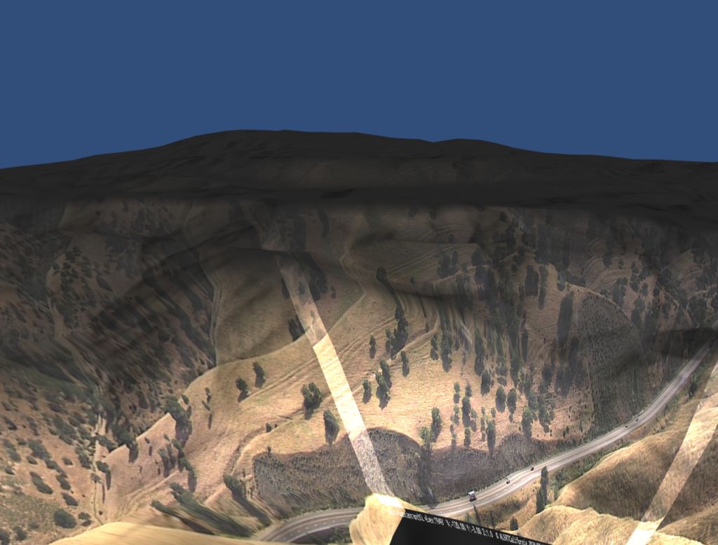
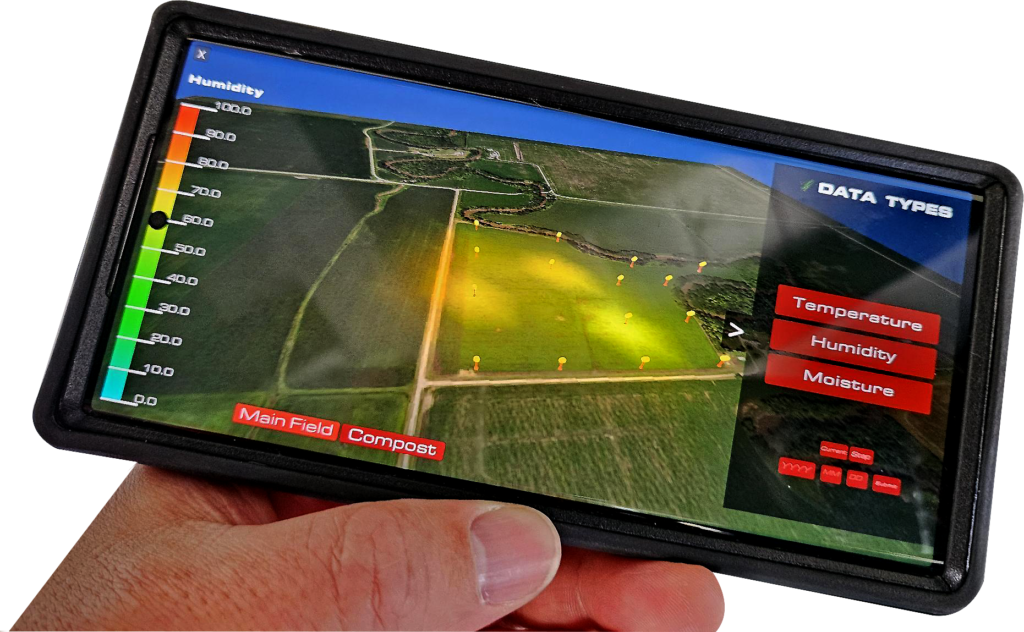
Ty Audronis founded Tempest Droneworx to put drone data to work. His idea? To replace that system with real-time, three-dimensional, multi-spectral mapping, which exactly where his company, Tempest Droneworx, comes in.
Development Partners | Accelerators / Vetting Partners | Strategic / Project Partners
Tempest prides itself in our large and growing ecosystem of partners. From hardware to software, we are continuously finding new partners to help us in our mission to prevent issues from becoming problems. Interested in partnering with us?
For any inquiries, please call or email us.
14701 St. Mary’s Lane, Suite 315
Houston, TX 77079
Tel: 281.675.2661
info@Tempestdroneworx.com
Copyright © 2025, Tempest Droneworx, Inc. – All Rights Reserved | Privacy Policy